
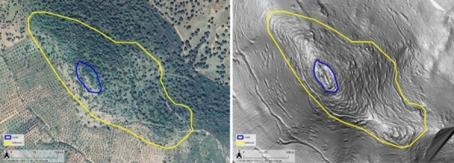
LiDAR (Light Detection and Ranging) technology is a tool used for archaeological prospecting in areas covered by dense vegetation. Researchers with the HUM-882 group at the University of Cordoba have discovered archaeological sites under the canopy of the Mediterranean forest by using this technology. Specifically, it allowed them to detect an ancient fortressand surrounding settlement at the Castle of El Viandar in El Hoyo (Belmez, Cordoba).
Thanks to its capacity to penetrate dense forest settings, it makes it possible to detect archaeological vestiges scattered in orographically complex areas. Digital Terrain Models (DTM) derived from LiDAR have facilitated the identification of topographic landscapes of archaeological interest. "LiDAR consists of millions and millions of laser points emitted from a drone or airplanes, touching all the highest points on a hill, treetops, brush, down to the ground. We classify them and record the points on the ground. It is so precise that the LiDAR detects any anomaly in the ground," explained Antonio MonterrosoCheca, the professor at the University of Cordoba responsible for the study.
The analysis covers the historical settlement area from the Chalcolithic to the Middle Ages, today completely covered by Mediterranean forest. Due to the dense canopy, and the fact that it is a protected area on private land, it had not been previously examined. Professor Monterroso points out that this is an area of important mineral wealth, and vital to travel between Badajoz and Córdoba. "One way to recover or promote the heritage is to study the most significant deposits in these areas, so as to better understand the history of Córdoba," he stated.
To reveal the settlement the research team mainly used a series of LiDAR mapping studies to collect data and analyse other National Geographic Institute of Spain (IGN) open access remote sensing resources. The IGN LiDAR data turned out to be of special interest. LiDAR, along with other products, was instrumental in identifying the site. Similarly, mapping surveys allowed them to analyse the limits and scope of the IGN aerial LiDAR and other open access remote sensing products. The research showed that low-cost products applied to LiDAR research in archaeology suffer from great limitations when it is necessary to have a high level of spatial resolution to define the design and the main components of an archaeological site.
References
Monterroso-Checa, A.; Moreno-Escribano, J.C.; Gasparini, M.; Conejo-Moreno, J.A.; Domínguez-Jiménez, J.L. Revealing Archaeological Sites under Mediterranean Forest Canopy Using LiDAR: El Viandar Castle (husum) in El Hoyo (Belmez-Córdoba, Spain). Drones 2021, 5, 72. https://doi.org/10.3390/drones5030072